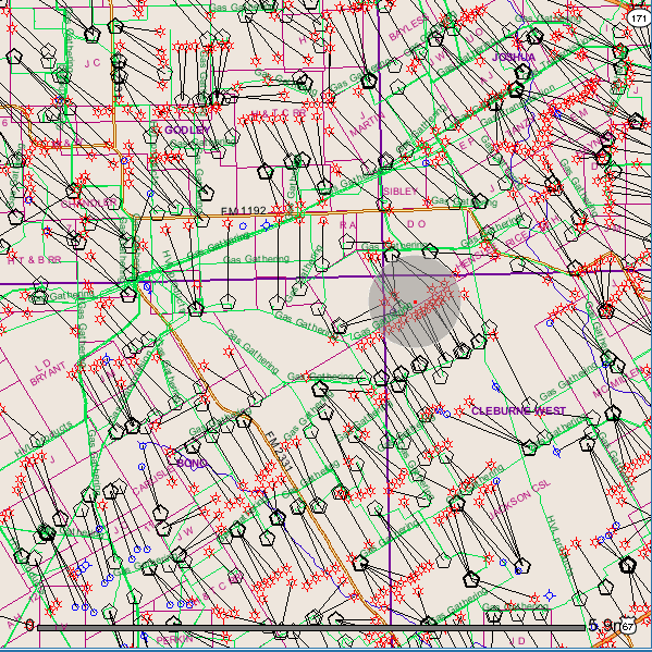
We just had another earthquake–3.2M–and it’s right in the heart of the Barnett Shale Gas Patch.
I will be back with more information in a bit. Until then, see earthquakes under the FAQs
Here is a Google Map of the area.
General area of quake shown in gray circle.

About Sharon Wilson
Sharon Wilson is considered a leading citizen expert on the impacts of shale oil and gas extraction. She is the go-to person whether it’s top EPA officials from D.C., national and international news networks, or residents facing the shock of eminent domain and the devastating environmental effects of natural gas development in their backyards.
- Web |
- More Posts(5121)
Wow. I sure hope those gas gathering lines did not get compromised from the quaking.
I know! And the well bore. YIKES!
Clearly you are both involved with this business. You will fall like everyone else. Burn in hell demons God is not on your side.
this is gods planet
we just live here for now
Yes, hopefully the oil lines and equipment are safe from earthquakes. Above all other things, we pray. I am happy as long as I can have relatively cheap gas. If the people living in that region experience earthquakes and polluted air and water as a direct result of fracking, so be it. What’s most important is that US / multinational oil companies are able to turn a profit and remain ‘competitive’ in the globalsphere. Yippee Ki yi yay!!!
Dawny, you are the problem with the world. I hope you are actually a person hired by these assholes to write something so evil. If not find a really high building and do us all a favor and jump.
That’s sarcasm, right ones. Lighten up.
Whoa.. Wastewater drilling adjacent? Any sense of aquifer impact? Yes, thinking about TX water, too. Quakes in AR, OK, CO, VA, WV, OH and TX.. what the frack? THX, Sharon. Awesome maps and details. Sharing. =@@= Tweetshake! / from a friend/ally in PA
Where did you get that map, and is there a key to the various symbols there?
Legend: http://gis2.rrc.state.tx.us/public/help/legend.html
Texas Railroad Commission GIS map http://www.rrc.state.tx.us/data/online/gis/index.php#
thanks much.
LOOK at that Map! Lots of paths from down there up to our drinking water aquifers so as to allow many, many migratory paths for drilling fluids, gasses, and fracking fluids to contaminate our water. The situation wasn’t so bad in the days of old when there was no surface pressure on old oil wells–but now, in the days of shale gas drilling/fracking where high pressures seek out migratory paths to our water–contamination will greatly accelerate.
Thank you Sharon for keeping us informed on the latest gas mafia happenings. You are much appreciated.